 Portions of the following information were taken from Florida Geological Survey Bulletin 66.
The springs are located within the Homosassa Springs Wildlife State Park and form the
headwaters of the Homosassa River. Coming from the north on US 19/98 into Homosassa
Springs, turn west (right) on CR 490A and travel 0.5 mile. Turn south (left) on access
road to Homosassa Springs Wildlife State Park and travel 0.3 mile to park entrance. The
spring pool, into which all three vents issue, is just below the underwater viewing
platform in the manatee rehabilitation area.
Description - Homosassa Springs Group forms the head of the Homosassa River, which
flows west approximately 6 miles to the Gulf of Mexico. Downstream from the head springs
about a mile, the spring-fed Halls River flows in from the north. The entire river
system is tidally influenced.
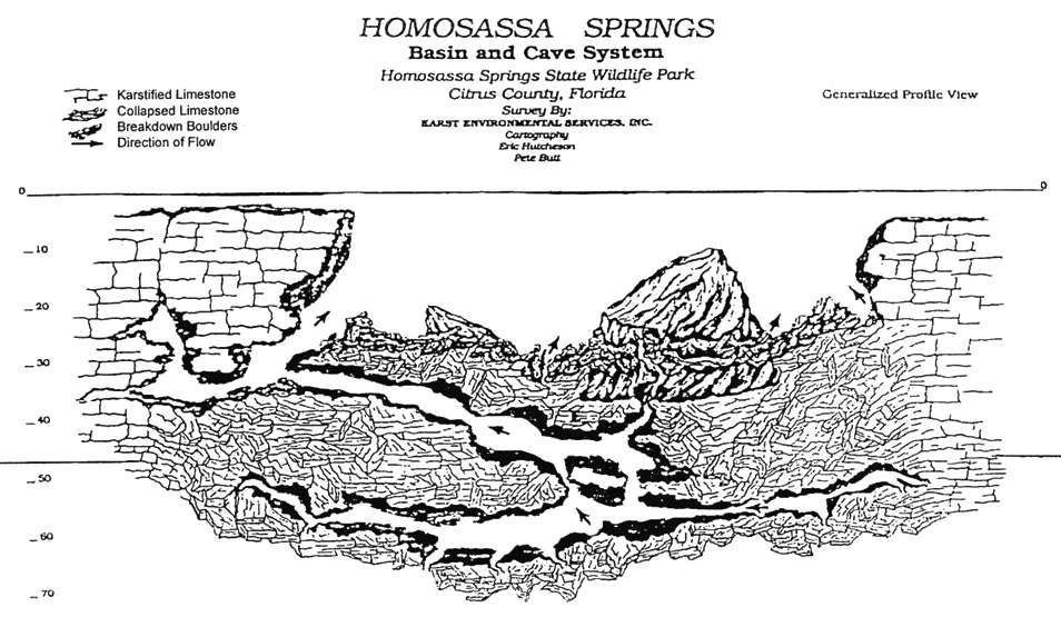
HOMOSASSA SPRINGS NOS. 1, 2, and 3 - All three vents issue into the same spring
pool. The pool measures 189 ft north to south and 285 ft east to west. The depth for each of
the vents is 67, 65, and 62 ft for spring nos. 1, 2, and 3, respectively. The springs issue
from a conical depression with limestone exposed along the sides and bottom of the spring pool.
The pool is teeming with salt water and freshwater fishes. Water is clear and light blue. There
is a large boil in center of pool. Surrounding land is Gulf Coastal Lowlands with thick
hardwood-palm forest cover. Approximately 1,000 ft downstream, a fence spans across the river
to keep boats out of the spring pool. There also is a barrier immediately outside the spring
area which keeps the captive manatees in the spring pool. Manatees frequent the spring pool
and river year round, but are especially common in winter. The springs are tidally influenced
year round, especially in winter.
Utilization - The main spring pool and adjacent lands are within Homosassa Springs Wildlife
State Park. The area is developed into an interpretive center for manatee and Florida wildlife
education. There is a floating observation deck in the spring pool with a submerged aquatic
observation room. Injured and rehabilitating manatees are captive in the spring pool for year
round observation. Swimming is not allowed.


