


United States » Citrus Blue |
| Overview | Location & Specifics | Conditions | Resources | Nearby Systems |
 Portions of the following information were taken from Florida Geological Survey Bulletin 66.
Citrus Blue Spring is located along the Withlacoochee River approximately 10 miles southeast of Dunnellon. From the US 41 bridge over the Withlacoochee River in Dunnellon travel south on US 41 approximately 1.3 miles to the intersection with CR 39. Head east (left) on CR 39 and travel approximately 7.6 miles to the intersection with CR 200. Head northeast (left) and travel 0.1 mile to the bridge over the Withlacoochee River at Stokes Ferry. A boat launch is on the southeast side of the river. The spring can be accessed by boating 3 miles upstream from the CR 200 bridge in Stoke's Ferry. The spring is situated on the south (right) side of the river.
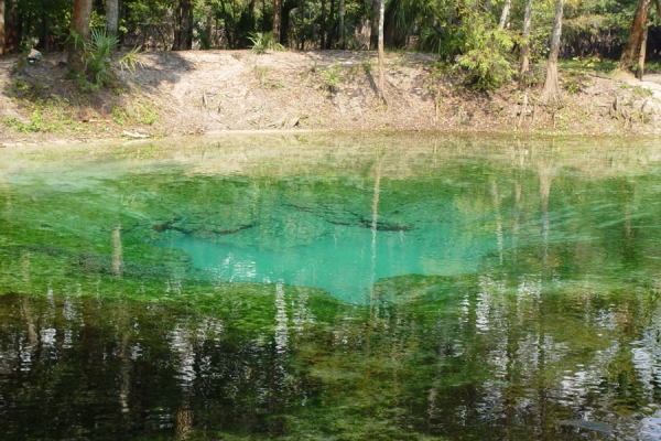
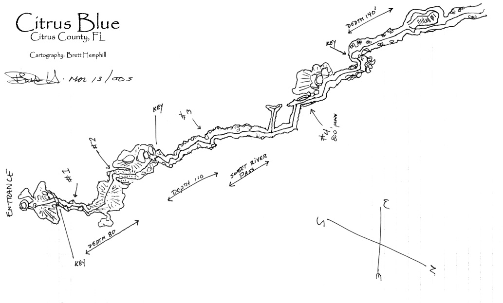
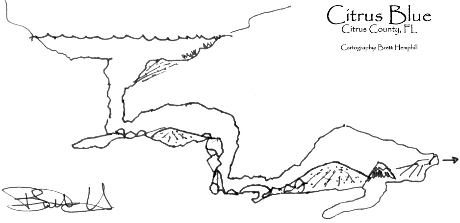
Description - Citrus Blue Spring has a roughly circular pool that measures 120 ft in diameter. The east side of the spring pool is partly enclosed by a man-made, five foot high dike. The spring depression is relatively shallow and uniform except at the vent in the center where depth measures 22 ft. A slight boil was observed over the vent during October 2002. The color of the water is bluish-green, and the sand bottom has substantial aquatic grass cover with sparse algae. Spring flow is directed northwestward through a 30 ft wide man-made canal, eventually discharging into the Withlacoochee River approximately 0.4 miles downstream. The canal has a sand bottom with abundant detritus as well as abundant aquatic vegetation. Before the dike was constructed, the spring apparently discharged eastward approximately 150 ft into the river. The spring is within the forested Withlacoochee River floodplain. The spring reportedly has an extensive cavern system that opens southward to a depth of at least 180 ft below the spring surface (Rosenau et al., 1977).
Utilization - Citrus Blue Spring is surrounded by private property and is used locally for swimming.
| Date | Submitter | Visbility | Remarks |
|---|---|---|---|
| 6/16/2018 | Sean/Cavedivecamp.com | 50 | Had no problem with shallow draft metal boat as River was just over 2 .6 ft at Holder Station on SR 200. Had to move a large Rock to clear side mount belly crawl squeeze through entrance. In the large room we found the line and Cave hopelessly buried in sand. Still a worthwhile trip as the river had lots of life including alligators the spring was beautiful the kids were entertaining and it was a first time at this site for my buddy T and I. |
| 5/14/2011 | Cary Ernst | N/A | Tried to make it to this spring but never made it. Some day Ill make it to this spring but not today. The boating trip to reach the spring was the worst part. Be very careful with this river. The water is very dark and the rocks are every where. I was in a 14 foot key west and even with the motor up as high as I could keep it and running at idle speed only, I was hitting rocks. The turning point for me was when The boat ran aground for the second time in the middle of the river. Had to get out of the boat and push it off the rocks then try to get back in the boat as it was being pushed back down stream. What a mess. Did however see 3 local boys heading to the spring is a 10 foot Jon boat with a 6 horse. It is a shame My boat just drafts to deep for the shallow river. Might come back at a later date if can get access to a shallower boat. Also if anyone know a way to access this spring other that boat please E-Mail me. Thanks. Cary. |
| 4/28/2009 | T-Shark | 50-60ft | Very low flow. Very Silty. We need rain. Still a nice cave, but a solo dive at the moment, and expect zero vis exit. Keep an eye on the line and how it is run. |
| 3/15/2005 | Joe Tegg | 100' | High Flow at the entrance. Once in, a beautiful cave with wonderful features. This cave has a lot of clay and will silt out, but the line is run in a good manner, so low vis on exit is not to bad. Sweet River Pass is a nice part of this cave... If one looks hard enough, there is a FULL turtle shell and gator's head in the first 100' of the cave. Sidemount is the only way to dive here. Also when flow is down, the cave turns to milk for the whole exit, so it's more fun when flow is up. :) |
| Description | Type | Date | Author | Remarks |
|---|---|---|---|---|
| Map | ||||
| Map |
| System | Depth | Cave | Cavern | OW | Last Report | Distance (mi) |
|---|---|---|---|---|---|---|
| 22 | 7/23/2014 | 11.8 |