United States » Hornsby Spring

  • Currently 2.7/5 Stars.
  • 1
  • 2
  • 3
  • 4
  • 5

Rated 2.7/5 stars (274 ratings) Thanks for rating this cave system!

Overview Location & Specifics Conditions Resources Nearby Systems  
Portions of the following information were taken from Florida Geological Survey Bulletin 66.

Hornsby Spring is located in Camp Kulaqua 1.5 miles north of High Springs. From the US 441/41 and CR 236 (Main Street) intersection in High Springs, drive north on US 441/41 approximately 1.5 miles to Camp Kulaqua which will be on the east (right) side of the road. Turn east (right) at Camp Kulaqua sign and follow road approximately 1 mile to campground entrance. The spring is located inside the campground about 300 ft northwest of the camp entrance.

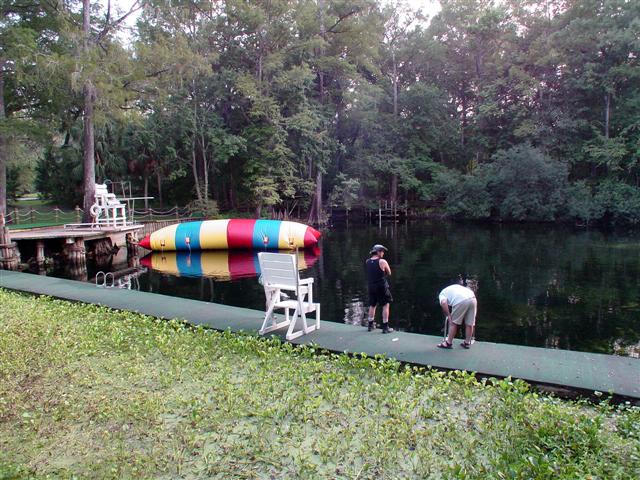
Description - Hornsby Spring has a circular spring pool measuring 155 ft north to south and 147 ft east to west. Its depth at the vent is 34.5 ft. The water is clear and slightly greenish blue. The spring has an underwater limestone ledge on the north side under a floating walkway. Algae patches are growing on limestone substrate. The spring run is approximately 0.9 miles long, 15 ft wide and up to 5 ft deep. It flows generally westward into the Santa Fe River. During the first FGS visit, the spring was not flowing. The FGS sampled the spring during a subsequent visit when a small spring boil was visible near the wooden walkway. This spring is situated on the edge of the lowland floodplain of the Santa Fe River. The floodplain is forested with cypress, gum, and maple. High ground on the east side of the spring rises steeply to 6 ft above water level, then gently rises to approximately 15 ft and is a rolling sand hills terrain. The uplands are open and 
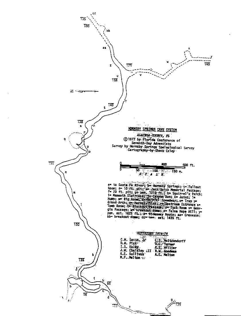
grassy. An underwater cave system has been mapped at Hornsby Spring.

Utilization - Hornsby Spring is the central feature of the privately-owned Camp Kulaqua. The spring is developed into a swimming and recreation area. There are numerous boardwalks over and around the spring. A slide leads into the spring pool on the north side. Full facilities are located nearby.
Click the map below for all mapping options.
Click to View Larger Map
Latitude: 29.8502393
Longitude: -82.5937281
Zone:
Coordinate System:
Maximum Depth: 190'
 Cave Diving
 Cavern Diving
 Open Water Diving
Closed
Date Submitter Visbility Remarks
Click here if you would like to contribute any information or resources for this system.
Description Type Date Author Remarks
 System Map Map
Sslect Search Radius:
System Depth Cave Cavern OW Last Report Distance (mi)
 Overview Information Available for Jug Spring  Jug Spring 80 True True False 1/12/2023 13.3
 Overview Information Available for Ginnie Springs - Devils Ear / Eye  Ginnie Springs - Devil's Ear / Eye 173 True True True 9/28/2021 6.3
   Syphon Creek - Myrtle's Fissure 95 True False False 2/29/2020 8.4
 Overview Information Available for Treehouse Spring  Treehouse Spring 65 True False False 9/1/2019 0.6
 Overview Information Available for Gator Hole Spring  Gator Hole Spring 115 True False False 6/7/2019 2.3
   Gator Hole Sink 115 True False False 5/18/2019 2.1
 Overview Information Available for Ginnie Springs - Ginnie Spring  Ginnie Springs - Ginnie Spring 60 False True True 9/25/2018 6.5
 Overview Information Available for Jesss Hole  Jess's Hole True False False 7/4/2017 3.5
 Overview Information Available for Wilson Spring  Wilson Spring True False False 7/18/2015 10.5
 Overview Information Available for Ginnie Springs - Dogwood Spring  Ginnie Springs - Dogwood Spring 43 True False False 9/7/2014 6.7
 Overview Information Available for Alachua Sink  Alachua Sink 227 True False False 1/11/2014 6.1
 Overview Information Available for Ginnie Springs - Little Devils  Ginnie Springs - Little Devil's True False False 7/1/2011 6.3
   Syphon Creek - Resurgence True False False 6/23/2011 8.4
   Vampire Sink True False False 11/21/2010 2.7
   Whippoorwill Sink False False False 1/31/2010 0.9
 Overview Information Available for Darby Spring  Darby Spring True False False 4/7/2009 0.8
   Old Bellamy - Sweetwater Lake 150 True True False 9/15/2007 2.7
   Old Bellamy - Two Hole Sink 160 True False False 3.3
 Overview Information Available for Sante Fe River Rise  Sante Fe River Rise 150 True True False 1.6
   Old Bellamy - Alligator Sink 160 True False False 3.3
   Old Bellamy - Mae Callie Pond 160 True False False 3.5
   Old Bellamy - Big Blue Sink 160 True False False 3.2
 Overview Information Available for Sawdust Spring  Sawdust Spring True False False 6.6
   Syphon Creek - Track One True False False 8.2
   Syphon Creek - Lil' Awesome 80 True False False 7.8
   Syphon Creek - Big Awesome 110 True False False 7.6
   Syphon Creek - Swallow Hole 188 True False False 8
   Old Bellamy - Pfv 150 True False False 5.3
   Old Bellamy - Pfc 150 True False False 5.5
   Old Bellamy - Bee Tree Sink 160 True False False 3.2