| 5/10/2015 |
RB Havens (via CDF) |
30-40 |
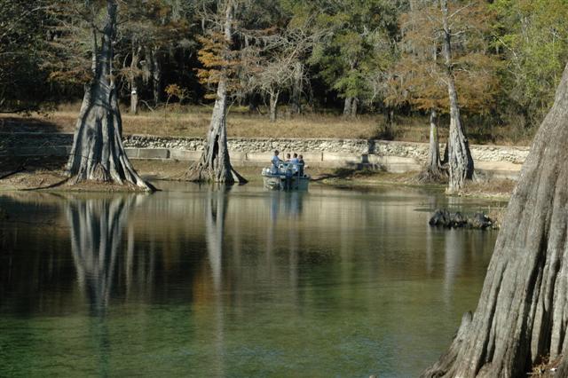
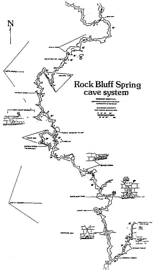
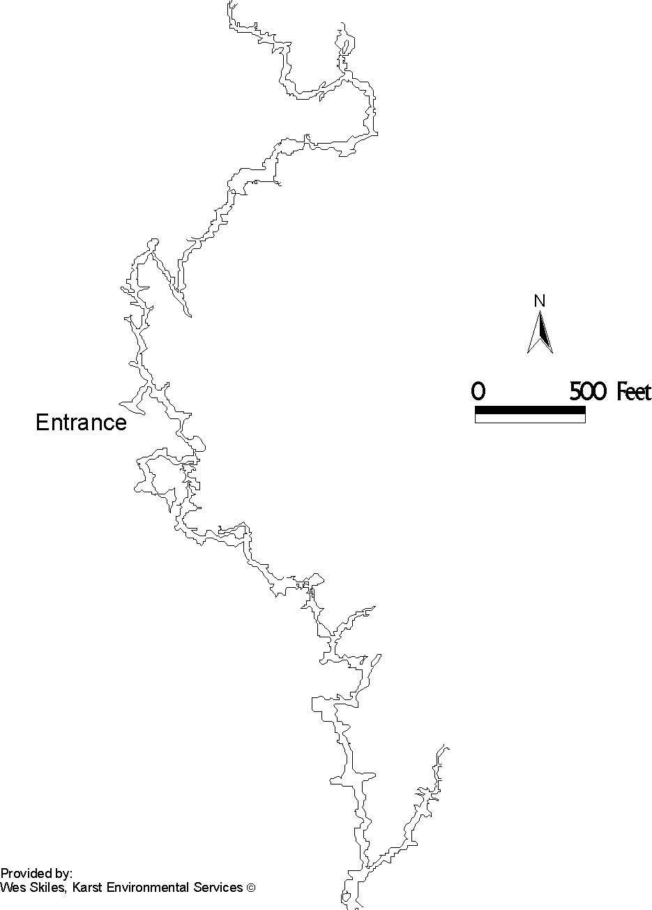
Dove Rick Bluff yesterday. Conditions are still nice, flow is down, viz about 30-40'. There is ALOT more sand at the entrance than when we tried to get in February and it was really pumping. No problem getting in, coming out I got a bit of a sand slide and it did a good job of jamming up my inflator and a couple of my bolt snaps. We noticed that the main line is loose in one section and getting pretty worn on some of the sharper edges/hard turns. I moved it up or down a couple of inches to smoother rock in a couple of places. |
| 4/3/2015 |
Teddy |
10 |
Flow minimal but present, visibility 10' during penetration. Entrance required a little digging, but was then easily passed through in SM 95's. |
| 2/12/2011 |
Tegg |
75 - 80 |
Flow was down, cave was nice as usual. |
| 12/8/2010 |
Jerry |
75 |
Flow isn't that bad. Entrance has a few rocks in it; pretty much normal. Vis is pretty good. dead deer in the run may get funky in a few days. |
| 12/5/2010 |
Tegg |
80' |
River is down so flow is decent. Vis was good inside the cave. Only had to dig out the entrance a little bit, so someone must have been there recently. |
| 7/26/2010 |
Jerry |
60 to 70 |
Good dive; river is dropping so the flow is picking up. Took the south route out to grim pickins. |
| 7/12/2010 |
James Garrett |
50ft |
Not terrible flow, entrance restriction is reasonable, not as difficult as it looks in the video. |
| 5/2/2010 |
Flyczek |
50 |
Easier entrance since the last flood, no need to dig in or out. Checked out the south side to the T. Flow was significant throughout. Lots of people hanging out in the spring pool on a nice spring day. |
| 1/18/2010 |
Flyczek |
20 |
River level is up and flow is barely noticeable. Had to dig a little to get in, but getting out was no problem. Cave looked orange in color, lots of particulate and dust on the south section. After turning, visibility had reduced to 10 feet due to falling dust. I peeked into the North section, it appeared much cleaner, possibly 30 feet vis. |
| 1/18/2010 |
Flyczek |
20 |
On second thought, I think I reversed my directions in the below post, North is South and vice versa. |
| 12/16/2009 |
Jerry |
60' |
Rising river level really suppressed the flow; we were able to swim in the entrance. Took the South Route out past Sheppard Sink. Still a decent flow to keep the silt moving in the cave. |
| 11/8/2009 |
Iowa Cave Diver |
60-70' |
flow-kickin', enterance... seemed the norm from what I hear (first time at this site) I had to move some rocks before attempting my enterance. Water was slightly greenish and still lots of silt build up on the rock projections and overhangs. Basin was very shallow with mung all over the bottom... great for the gear. No bugs! Bats were overhead everywhere as we exited in our inflatable back to the boat ramp.
**I experienced a broken line on exit and had to run a safety reel to search/locate and reconnect to the mainline. Not having gas to go back and check for placement or security, I had to exit. My replacement line should be a short way past the upsidedown restriction in the south passage. First team in may want to bring some line in case the line needs to be re-run or adjusted for safety. Details of my dive can be found on www.cavediver.net
|
| 10/13/2009 |
Jerry |
30-50 |
Rich and I had a great dive; the flow is ripping. There is still a lot of particulate in the water and on the walls. The water has a strong green color instead of the normal blue. Did the South route to Beaver Spring and back; recalculated and went up the North route. Had a great :80 dive! |
| 8/8/2009 |
Billy Fowler |
50 |
Absolute fabulous; the flow is ripping and has blown out the entrance so a shovel wasnt necessary but it was difficult getting in due to the flow and nothing solid to hold on to. Both routes have a good amount of flow, as well as some of the side jumps off of the north route. |
| 1/25/2009 |
Jerry |
40' |
Great dive; river is coming down. Flow is up in the cave; even the North Route has flow. It only took 5 mins of digging to open the entrance enough to get in. Easy dive after that. |
| 12/26/2008 |
Jerry |
0 |
Rise in river level has caused the spring to reverse; it is black. |
| 10/5/2008 |
Jerry |
20-25 |
System is still tannic but clearing; took a fair bit of digging to get in. Good flow in the system, even the North Route has good flow. Should get better as the river drops. Good dive! |
| 2/2/2008 |
Eric Deister |
60 |
First time in there, yes you need a shovel to get in. Great dive, almost went end to end. South route was VERY silty. |
| 12/29/2007 |
Jerry |
50 |
Jill and I did the South Route---amazing cave; smaller than the North Route so the flow keeps the silt clear. The Flip-Over Restriction isn't too bad. Entrance hasn't changed---a shovel helps. If you hang in hte en restriction the sand slope will try to lock you in. |
| 9/7/2007 |
Jerry |
60 |
Dove with Wayne Kinard; water is way down; flow is still impressive. Used a shovel to clear about 6 inches of debris from entrance it was still very tight--Wayne reported 6 inch or better rocks shooting out when I blocked entrance--flow very manageable once inside; North Route is larger but siltier went about 600 ft. South Route is clear with gravel floor went to the Flipover restriction and turned. Make sure your side-mount rig is tight and tanks trimmed to get through the entrance restriction. Great dive; need a boat and watch out for leaping sturgeon! |


 Portions of the following information were taken from Florida Geological Survey Bulletin 66.