United States » Owens Spring

  • Currently 2.7/5 Stars.
  • 1
  • 2
  • 3
  • 4
  • 5

Rated 2.7/5 stars (282 ratings) Thanks for rating this cave system!

Overview Location & Specifics Conditions Resources Nearby Systems  
Portions of the following information were taken from Florida Geological Survey Bulletin 66.

Owens Spring is located on SRWMD land about 8 miles east of Mayo. From the intersection of US 27 and SR 51 in Mayo head east on US 27 for approximately 6.8 miles to the intersection with CR 251. Turn east (left) onto CR 251 and drive approximately 2 miles until the road makes a 90 degree bend to the north. Continue on CR 251 north approximately 0.7 miles until the road comes to an end at a boat landing. The spring pool is approximately 0.25 miles east of the CR 251B boat ramp on the Suwannee River.

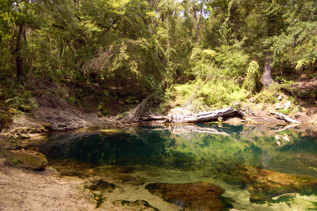
Description - Owens Spring pool measures 114 ft north to south and 87 ft east to west. The pool is shallow, less than 8 ft deep except in the deepest area at the vent where it measures 31.3 ft deep. The vent lies beneath a submerged limestone ledge on the southwest side of the pool. The water is clear bluish to slightly tannic. There is very little aquatic vegetation and the bottom is mainly rock and sand. There are thick patches of dark green filamentous algae covering more than half of the pool substrates.

Owens Spring has steep limestone and sand banks. Its west and north banks rise vertically to approximately 20 ft higher than the water surface. In July 2002, the spring had a short run with steep sandy banks. It flowed approximately 125 ft northeast into a siphon. Also at this time, the spring was barely flowing, crystal clear, and averaged less than 1 ft deep.

At higher water levels Owens Spring flows overland through a lowland corridor leading to the Suwannee River. This intermittent channel is dotted with sinkholes and karst windows, and limestone frequently is exposed along its course. A gated sand road accesses the spring on the south side where there is a small gravel parking area. All surrounding lands are forested with mixed hardwoods and pines.
Click the map below for all mapping options.
Click to View Larger Map
Latitude: 30.045944
Longitude: -83.041125
Zone:
Coordinate System:
Maximum Depth: 45'
 Cave Diving
 Cavern Diving
 Open Water Diving
Date Submitter Visbility Remarks
10/7/2019 Sean McCarthy excellent The springs confluence with the Suwannee is almost visible due to low water levels.
6/6/2015 Cavedivecamp.com 30' took my snorkeling gear here today to check out conditions and potential for a cave dive. good flow heading to the downstream side of the sprng pool. big tree over cave opening and 30 foot depth makes snorkeling challenging. will definitely be back with a scuba tank.downstream vents look fun but small.
Click here if you would like to contribute any information or resources for this system.
Description Type Date Author Remarks
Sslect Search Radius:
System Depth Cave Cavern OW Last Report Distance (mi)
 Overview Information Available for Little River  Little River 110 True True True 3/15/2024 5.6
 Overview Information Available for Cow Spring  Cow Spring 110 True False False 1/20/2024 6
 Overview Information Available for Telford Spring  Telford Spring 80 True False False 8/17/2023 8.6
 Overview Information Available for Ruth Spring  Ruth Spring 50 True False False 6/11/2023 5.2
 Overview Information Available for Peacock Springs - Peacock III  Peacock Springs - Peacock III 214 True False False 3/12/2023 7.6
 Overview Information Available for Peacock Springs - Peacock I  Peacock Springs - Peacock I 175 True True False 11/17/2022 7.6
 Overview Information Available for Royal Spring  Royal Spring 50 True True True 11/15/2022 3.3
 Overview Information Available for Alligator Rescue Spring  Alligator Rescue Spring True False False 5/20/2022 8.4
 Overview Information Available for Peacock Springs - Orange Grove  Peacock Springs - Orange Grove 175 True True True 3/30/2022 7.8
 Overview Information Available for Troy Spring  Troy Spring 70 False True True 9/16/2020 3.8
 Overview Information Available for Suwannee Blue Spring  Suwannee Blue Spring 40 True False False 6/28/2016 2.9
 Overview Information Available for Convict Spring  Convict Spring 30 True False False 11/23/2015 4.4
 Overview Information Available for Mearson Springs  Mearson Springs True False False 6/6/2015 1
 Overview Information Available for Peacock Springs - Peacock II  Peacock Springs - Peacock II True False False 4/8/2015 7.6
 Overview Information Available for Peacock Springs - Waterhole III  Peacock Springs - Waterhole III 55 True False False 9/26/2013 7.7
 Overview Information Available for Bathtub Spring  Bathtub Spring 20 True False False 2/5/2011 4.7
 Overview Information Available for Peacock Springs - Baptizing Spring  Peacock Springs - Baptizing Spring True False False 8/15/2010 8.4
 Overview Information Available for Branford Spring  Branford Spring 101 True False False 1/16/2010 9.2
 Overview Information Available for Bonnet Spring  Bonnet Spring 48 True False False 8/15/2009 7.9
 Overview Information Available for Hidden Spring  Hidden Spring True False False 6/1/2006 5.9
   Double Sink True False False 6.9
 Overview Information Available for Running Springs  Running Springs False False False 6